Anticipate risks, accelerate response, and protect
large-scale operations

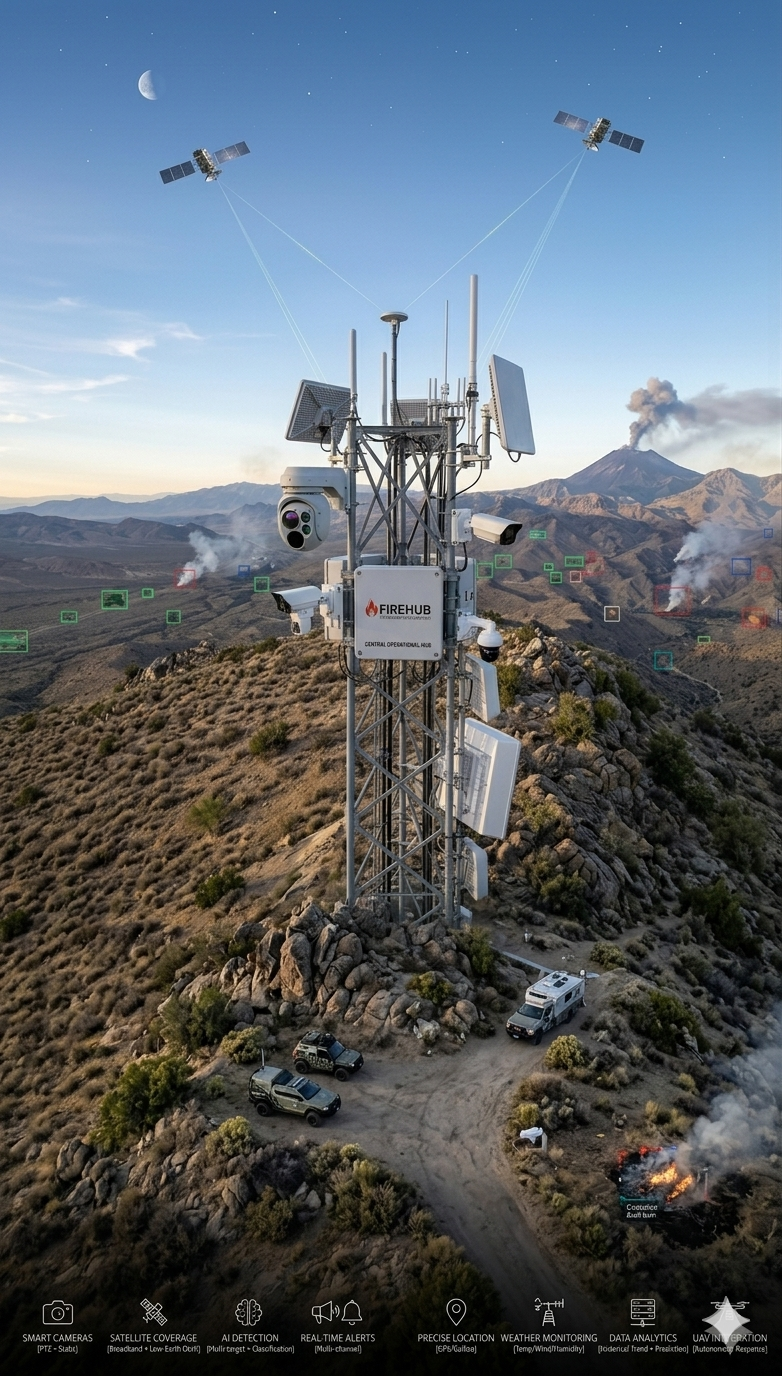
FIREHUB: Fire Intelligence from Ground to Satellite

FIREHUB — anticipate risk, accelerate response, and protect large-scale operations

FIREHUB brings together computer vision, satellite monitoring, and artificial intelligence to turn wildfire risk management into a precise, automated, real-time operation.

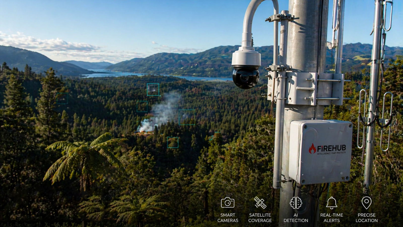
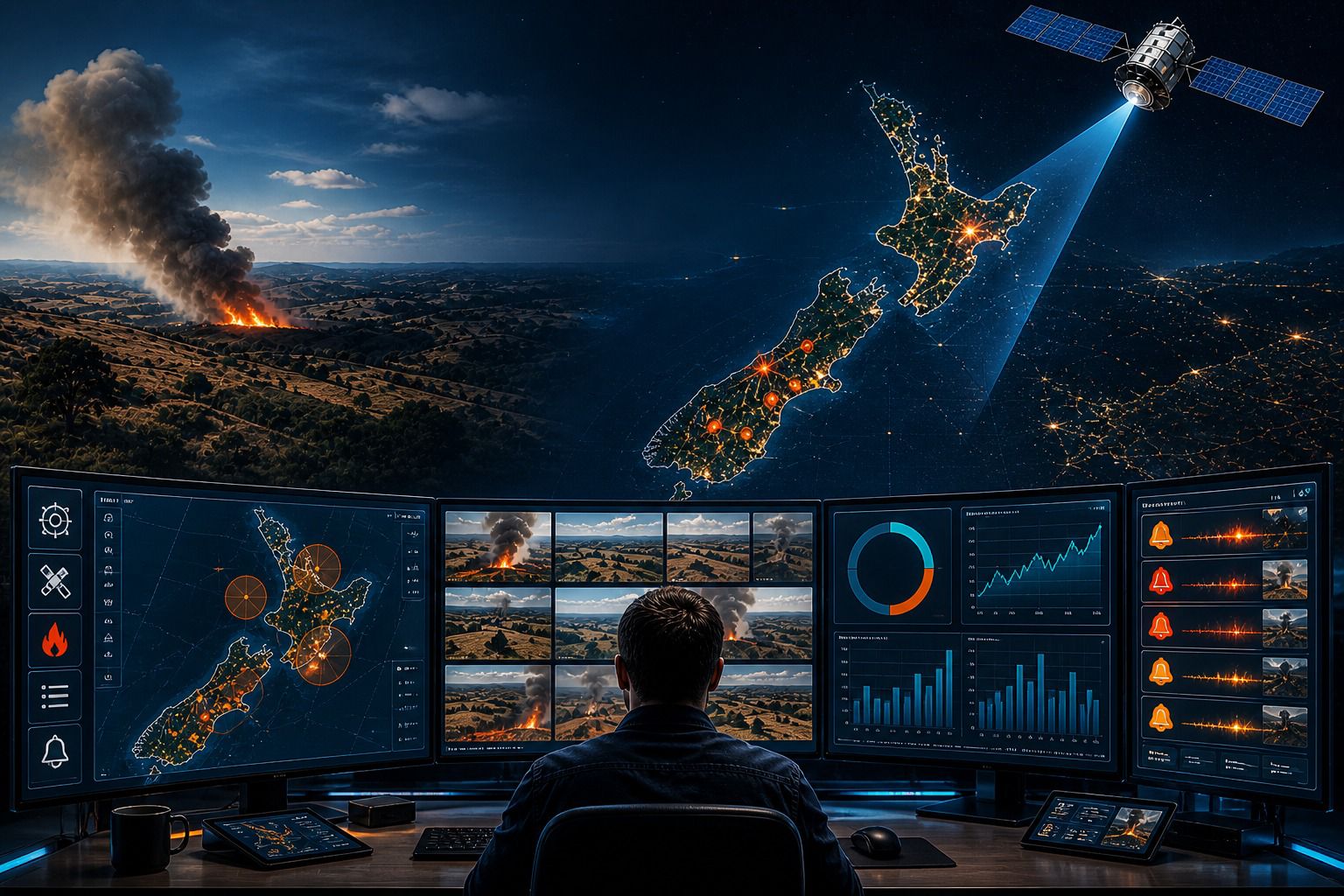
From the first trace of smoke in the field to a full view of the event at national scale, every layer of the system is designed to anticipate risk, speed response, and protect large-scale operations.

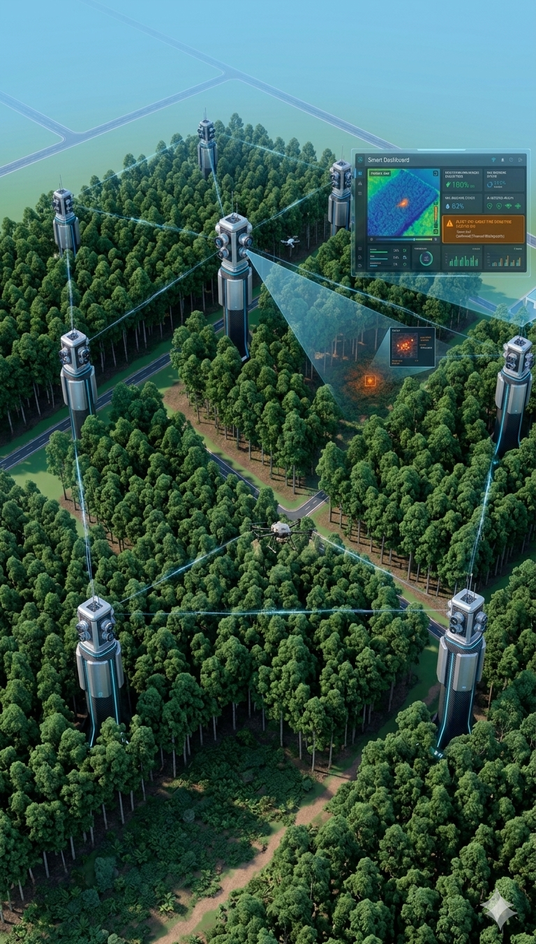
With a protected-area (hectare) approach, FIREHUB gives large landholders and insurers continuous control over risk exposure—reducing losses, improving decisions, and increasing operational predictability.

More than monitoring, FIREHUB connects detection, analysis, and action in one platform—turning data into immediate response.

Core modules

From detection to decision in one continuous flow

Explore the three layers of FIREHUB that connect farm-level AI detection, the operational map, and national satellite coverage.

Early AI detection at farm level — smart cameras and smoke signatures
01

Early Detection with AI (Farm Level)

Continuous monitoring with smart cameras that pick up early smoke signatures before a fire is visible to the naked eye—enabling immediate response.

Real-time operational map — hotspots, risk zones, and operation coverage
02

Real-Time Operational Map

A unified view with active hotspots, risk areas, and full operation coverage—from farm level to national level.

National satellite coverage — thermal anomalies and large-scale fire hotspots
03

National Satellite Coverage

Full territory visibility with detection of thermal anomalies and large-scale fire hotspots—so no event goes unnoticed.

Field operations and aerial view integrated with FIREHUB for wildfire risk management

Smarter Monitoring Control

Monitor with precision, adapt in real time, eliminate blind spots.

FIREHUB’s monitoring stack is built for large-scale, real-world operations. Smart cameras run continuously in the field while the satellite layer provides broad coverage—automatically tuning analysis to environmental conditions, visibility, and risk.

Whether you are watching thousands of hectares or zooming in on a higher-exposure area, FIREHUB intelligence blends local detection with national-scale visibility so every event is identified accurately and at the right moment.

With multi-layer validation (cameras + satellite), continuous operation even in adverse conditions, and integrated geospatial analysis, FIREHUB removes guesswork and delivers dependable monitoring without relying on manual intervention.

FIREHUB plans

Fire intelligence that scales with your operation

included or full tier · partial or limited · not included in this plan

Essential
  • Best for: small farms
  • Camera detection (AI)
  • Real-time alerts
  • Operational map: Basic
  • Data dashboard: Basic
  • Hectare risk analysis (AI): Basic
  • Weather integration: Limited
  • Satellite monitoring
  • Fire spread forecasting
  • Multi-region coverage
  • Systems integration (API)
  • Insurer integration
  • Automation & response (drones)
  • Advanced predictive AI
  • Customization
  • Support: Standard
Pro
  • Best for: mid-sized operations
  • Camera detection (AI)
  • Real-time alerts
  • Operational map: Advanced
  • Data dashboard: Advanced
  • Hectare risk analysis (AI)
  • Weather integration
  • Satellite monitoring: Partial
  • Fire spread forecasting: Limited
  • Multi-region coverage
  • Systems integration (API): Limited
  • Insurer integration
  • Automation & response (drones)
  • Advanced predictive AI: Partial
  • Customization
  • Support: Priority
Enterprise
  • Best for: insurers / industrial ag
  • Camera detection (AI)
  • Real-time alerts
  • Operational map: Custom
  • Data dashboard: Custom
  • Hectare risk analysis (AI): High precision
  • Weather integration
  • Satellite monitoring
  • Fire spread forecasting: Advanced
  • Multi-region coverage
  • Systems integration (API): Full
  • Insurer integration: Full
  • Automation & response (drones)
  • Advanced predictive AI: Full
  • Customization: Full
  • Support: Dedicated

Highlight

Recommended plan: Scale (most popular)

Intelligent Control Panel

Full visibility of your operation — in real time, with no blind spots.

FIREHUB brings your entire monitored area into one operational interface. From farm level to national coverage, you track events, risks, and alerts in real time with precision.

AI-enabled cameras pick up early signals in the field, while the satellite layer widens the view and confirms events at scale — all integrated in one clear, fast, actionable panel.

With dynamic maps, per-hectare risk indicators, and continuous environmental data, FIREHUB turns monitoring into immediate decisions. In the office or in the field, you have full control over what is happening — as it happens.

Key features

Real-time monitoring with cameras + satellite
Fire hotspot identification with precise geolocation
Area-based risk analysis (hectares) with AI
Integration with weather data (wind, temperature, humidity)
Dashboard with operational metrics and event history
Smart, prioritized alerts
Collaborative access across teams and operations
Control from Anywhere · Mobile (in development)

Real-time intelligence in your pocket

FIREHUB mobile experience preview

Keep full visibility of your operation—whether you are in the field, the office, or anywhere else. The FIREHUB app gives you full access to AI camera monitoring and satellite coverage, so you can track events, risks, and alerts in real time, straight from your phone.

With a simple, action-oriented interface, you see fire hotspots, risk areas, and critical environmental changes the moment they happen. Even in remote regions, the system keeps data continuity and automatic synchronization so no important information is lost.

Built for fast decisions, FIREHUB connects detection, analysis, and response in one mobile experience—putting operational control literally in your hand.

Key features

Ranked push alerts with ack / delegate flows
Live tiles plus lightweight streaming previews
Spot confirmations and photo evidence capture
GPS tracks for patrols and aviation coordination hooks
Secure team messaging tied to each incident
Bi-directional sync across phones, tablets, and SOC walls
  • Download option 1
  • Download option 2
Frequently Asked Questions

FIREHUB — FAQ

Quick answers about technology, coverage, integration, and value model.

  • Up to 70% reduction in detection time
  • Reduction of wildfire losses at large scale
  • Monitoring of thousands of hectares in real time
  • Response up to 5× faster in critical events

FIREHUB is an intelligent monitoring platform that uses AI-enabled cameras and satellite data to detect fires in real time, analyze risk, and protect large areas such as farms, forests, and insurer portfolios.

The system combines three layers:
  • AI cameras → detect smoke and fire early
  • Satellite → expands visibility to regional/national scale
  • Predictive AI → analyzes weather, vegetation, and risk
Everything is integrated into a single dashboard with real-time alerts.

Yes. The system uses computer vision to identify smoke and fire patterns even at early stages, generating automatic alerts with precise location.

Detection happens in real time, usually at the first visual signs (smoke), before the fire spreads.

FIREHUB scales by hectare. It can monitor from small properties to millions of hectares (insurer or country level).

FIREHUB charges based on protected area: NZ$ 8 to NZ$ 25 per hectare (depending on the plan). You pay for area under risk — not per user or camera.

Because it aligns with real financial risk: more area = more risk = more value; more value = higher willingness to pay. Unlike traditional SaaS (per user), ticket size grows naturally here.

Depending on the plan:
  • AI camera monitoring
  • Satellite coverage
  • Real-time dashboard
  • Smart alerts
  • Per-hectare risk analysis
  • Integrated weather data

Both. It detects real-time events and also predicts risk based on weather, wind, temperature, and vegetation condition.

Alerts are instant, geolocated, and risk-prioritized. They can be delivered via dashboard and system integrations.

FIREHUB mobile is being developed and will provide event visibility, real-time maps, alerts, and support for fast decision-making.

Yes. It can integrate with insurer systems, agricultural platforms, ERPs, and emergency operations.

No. It works for farms, forests, industrial areas, critical infrastructure, and insurer portfolios.

Fires cause billion-dollar losses and are unpredictable, fast, and hard to monitor. FIREHUB turns this into monitored, detectable, and manageable risk.

Customers use FIREHUB to reduce claims (insurers), protect agricultural production, and avoid million-dollar losses.

Because risk is directly linked to area: more area = more exposure and more protected value.

No. It complements them: cameras = local precision, satellite = scale. Together = complete coverage.

Yes. FIREHUB uses secure infrastructure for data storage and processing.

Full integration: camera + satellite + AI, detection + prediction, local + national.

Bottom line: FIREHUB does not compete as just software. It positions itself as essential infrastructure for any operation exposed to physical risk. The larger the territory, the larger the market; the higher the risk, the higher the value.

Interested in FIREHUB?

Contact us for demos, partnerships, or questions—we're happy to help.